During 2010 the Ontario Ministry of Natural Resources developed new forest plans for the crown land in our area for the next 10 years (2011‐2021). KAPOA reviewed and provided feedback on the plans at that time and we continue to monitor the forestry activities taking place in our area. We reported on the forestry planning exercise at the 2010 AGM.
To review the plans and annual work schedules and to learn about how MNR manages forestry on crown lands please refer to the MNR web site: http://ontario.ca/forestplans
Our area is divided into two Forest Management Units. While each forest management unit follows the same forest planning manual, the plans are developed independently.
- Bancroft‐Minden FMU 220 – managed out of the MNR Bancroft office
- Ottawa‐Valley FMU 780– managed out of the MNR Pembroke office
There are many aspects to forestry in our area. Operations consist of harvesting but also replanting, tending, renewal and maintenance and road building. The details of each year’s activities are outlined in the Annual Work Schedule text and on a series of summary and operations maps.
Additional Resources
- Ontario Crown Land Policy Atlas – interactive map of crown land around Kamaniskeg Lake
- Ontario Forests: Ministry of Natural Resources
Ottawa-Valley Forest Management Unit

Contact: Rick Watchorn, MNR District Manager, (613) 735-5520
- Final Plan Phase I (2006-2026)
- Forestry Mgmt Plan Summary 2011 to 2021 for Ottawa Valley
- Forestry Mgmt Plan Summary 2006 to 2011 for Ottawa Valley
- Ottawa Valley Forest Industry
- 5 year Environmental Assessment Report (Ministry of Natural Resources)
Bancroft-Minden Forest Management Unit
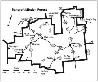
Contact: Gareth Davies, MNR Area Forester, (613) 332-3940 ext 248
- Open House Details: June 5th Sword Motor Inn Bancroft
- Proposed Long-Term Management Direction 2011-2021
- Final Plan Phase I (2006-2026)
- Annual Work Schedule (2010 – 2011)


